
 E-mail Alert
 RSS
RSS
-
摘要
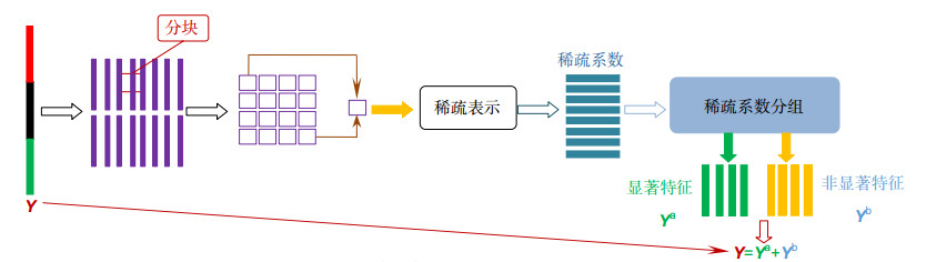
卫星云图能从多角度展示各类云系特征及其演变过程,实现基于内容的云图检索在天气实况监测、气候研究等方面具有重要意义。为了优化云图的组合特征,增强其组合特征的泛化能力,本文提出一种结合稀疏表示和子空间投影的特征优化方法。首先分别提取云图的颜色、纹理以及形状三种特征,并对其组合特征进行转换分块;然后对每一块的特征进行稀疏表示,根据不同原子的方差来分组特征,得到显著特征和非显著特征;最后由分组特征的能量来计算得到子空间投影矩阵,将初始的组合特征在投影矩阵上进行投影,得到优化后的云图特征。实验结果表明,本文优化云图特征的方法在查准率、查全率上均优于常用的降维方法和云图检索技术,对组合特征具有较强的优化能力,在实时检索过程中时间复杂度低,是一种全新的检索方法。

Abstract
Satellite cloud imagery can show the features and the evolution processes of all kinds of cloud systems from different aspects. Thus, adopting the content-based cloud image retrieval makes a big difference in supervising present weather conditions and studying the climate change. In order to optimize the combined features of the cloud picture and strengthen the generalization ability of its combined features, this paper presents an optimal method of combining the features of the sparse representation with the subspace projection. At first, we should extract its color, texture and shape, convert all the combined features, and divide them into different blocks. Then, we can make the sparse representation for each block's features, grouping them according to different atom variance and gaining both noticeable and unnoticeable features. Finally, we can count the power of the grouped features to get the subspace projection matrix, projecting the original combined features on it and achieving the optimal cloud picture features. The experiment turns out that the method of optimizing the cloud picture features in this paper is better than common descending dimension method and cloud retrieval technology in precision ratio and recall ratio. It indeed has a stronger optimization in the combined features as well as a lower time complexity in the process of the real-time retrieval, which indicates a brand new retrieval method.
-
Key words:
- sparse representation /
- feature optimization /
- subspace learning /
- cloud retrieval
-
Overview

Overview: The satellite cloud image can show the characteristics of the cloud system and its evolution process from multiple angles. The research of cloud image retrieval is of great significance for weather monitoring and climate research. In the design and implementation of cloud image retrieval system, feature extraction is the key link. Since different types of cloud image features have their own advantages when portraying cloud images, combining different types of features will help improve the performance of cloud image retrieval system. However, since the combined cloud image features tend to be too high in dimension, the time cost is often high in the similarity measurement phase, and there is redundancy between the feature vectors. In view of the above problems, this paper combines sparse representation and subspace projection technology to propose a dimension reduction method for cloud image combination features. Firstly, the content information of the cloud image is drawn from different angles, that is, the three features of the cloud image color, texture and shape are extracted. After that, the three features are normalized and cascaded into a combined feature vector, and then the combined feature vector is matrixed. The form is arranged, and the matrix is subsequently subjected to block processing. Then, each block is sparsely represented, the variance of each feature block sparse representation coefficient is calculated, and the feature blocks are grouped according to the variance obtained by different blocks and grouped by grouping. It is then possible to separate the initial combined features into salient features and non-significant features. At this point, a subspace will be searched, in which the significant part is preserved, and the non-significant part will be suppressed. A projection matrix can be obtained by learning training to achieve the combined feature dimension reduction. In the retrieval stage, the initial cloud image combination feature vector is projected on the projection matrix, and the dimensionality reduction cloud image feature can be obtained, so that the cloud image retrieval can be realized quickly and accurately. The experimental results show that the cloud image retrieval system achieved by this method is superior to the traditional dimensionality reduction method in the accuracy and recall rate of the cloud image retrieval system, and the time complexity of the retrieval process is low. This indicates that the proposed method has strong dimensionality reduction ability for cloud image combination features, and provides a new idea for cloud image feature dimension reduction and efficient cloud image retrieval system.
-

-
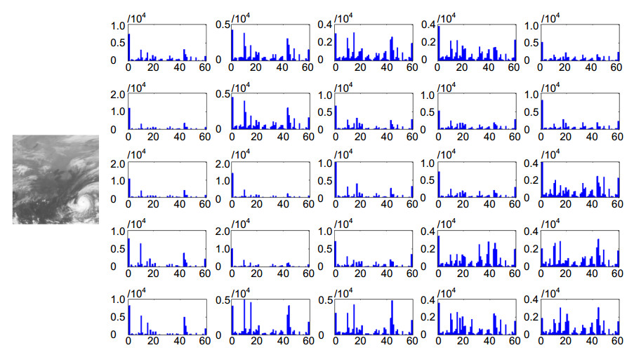
图 2 云图分块ULBP统计直方图特征
Figure 2. Cloud image divided block ULBP statistical histogram features
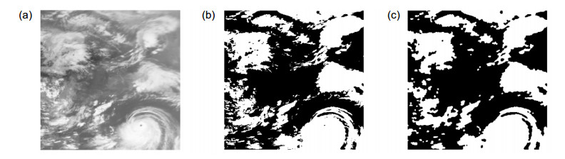
图 3 分割、开闭运算后的效果。(a)原图;(b)开运算后效果;(c)闭运算后效果
Figure 3. The effect after segmentation, open and close operation. (a) Original; (b) The effect of open operation; (c) The effect of close operation
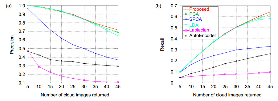
图 9 不同返回数目下的查准率(a)和查全率(b)变化曲线图
Figure 9. Curves of precision (a) and recall (b) under different number of returns
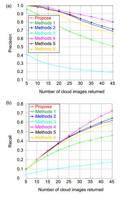
图 10 不同返回数目下的查准率(a)和查全率(b)曲线图
Figure 10. Curves of precision (a) and recall (b) under different number of returns
表 1 文中相关的参数设置
Table 1. Related parameter settings in paper
Parameter l m t s n z k d v v' Size 1200 1600 40 40 4 16 100 128 800 500  下载: 导出CSV
表 2 文中相关的矩阵维数
Table 2. Related matrix dimensions in paper
Dimension of matrix P1 P2 P W Y Ya=Yb Hi H Size 1600×800 800×500 1600×500 500×1200 1600×1200 1600×1200 16×100 16×433200
下载: 导出CSV
表 3 六种降维方法的查准率对比
Table 3. Comparison of precision of six dimensionality reduction methods
Number of cloud image return Proposed PCA SPCA LDA Laplacian AutoEncoder 5 1.000 1.000 0.967 1.000 0.475 0.467 10 0.987 0.983 0.838 0.987 0.288 0.425 15 0.964 0.953 0.717 0.961 0.225 0.372 20 0.931 0.927 0.619 0.938 0.179 0.354 25 0.897 0.888 0.545 0.885 0.153 0.348 30 0.843 0.838 0.499 0.838 0.131 0.328 35 0.794 0.787 0.443 0.777 0.117 0.315 40 0.754 0.734 0.401 0.717 0.113 0.303 45 0.716 0.688 0.369 0.648 0.107 0.294
下载: 导出CSV
表 4 六种降维方法的查全率对比
Table 4. Comparison of recall of six dimensionality reduction methods
Number of cloud image return Proposed PCA SPCA LDA Laplacian AutoEncoder 5 0.100 0.100 0.097 0.100 0.048 0.047 10 0.198 0.197 0.168 0.198 0.058 0.085 15 0.289 0.286 0.215 0.288 0.068 0.112 20 0.373 0.371 0.248 0.375 0.072 0.142 25 0.448 0.444 0.273 0.443 0.077 0.174 30 0.506 0.503 0.299 0.503 0.078 0.197 35 0.556 0.551 0.310 0.544 0.082 0.221 40 0.603 0.588 0.321 0.573 0.090 0.243 45 0.644 0.619 0.332 0.583 0.097 0.265
下载: 导出CSV
表 5 7种检索方法的特征维度大小
Table 5. Feature dimension size of seven retrieval methods
Retrieval methods Propose Methods 1 Methods 2 Methods 3 Methods 4 Methods 5 Methods 6 Size of feature 500 256 1475 8 1012036 1738 4096
下载: 导出CSV
表 6 7种检索方法的查准率对比
Table 6. Comparisons of the precision of the seven retrieval methods
Number of cloud image return Propose Methods 1 Methods 2 Methods 3 Methods 4 Methods 5 Methods 6 5 1.000 0.958 1.000 0.408 1.000 1.000 1.000 10 0.987 0.896 0.996 0.337 1.000 0.983 0.992 15 0.964 0.817 0.964 0.294 0.981 0.953 0.944 20 0.931 0.750 0.931 0.265 0.944 0.927 0.890 25 0.897 0.685 0.883 0.242 0.917 0.888 0.827 30 0.843 0.636 0.824 0.222 0.890 0.843 0.775 35 0.794 0.586 0.775 0.213 0.864 0.794 0.731 40 0.754 0.546 0.733 0.203 0.833 0.754 0.693 45 0.716 0.510 0.689 0.193 0.803 0.716 0.660
下载: 导出CSV
表 7 七种检索方法的查全率对比
Table 7. Comparisons of the recall of the seven retrieval methods
Number of cloud image return Propose Methods 1 Methods 2 Methods 3 Methods 4 Methods 5 Methods 6 5 0.100 0.096 0.100 0.041 0.100 0.100 0.100 10 0.198 0.179 0.199 0.068 0.200 0.197 0.198 15 0.289 0.245 0.289 0.088 0.294 0.286 0.283 20 0.373 0.300 0.373 0.106 0.378 0.371 0.356 25 0.448 0.343 0.442 0.121 0.458 0.444 0.413 30 0.506 0.382 0.494 0.133 0.534 0.506 0.465 35 0.556 0.410 0.542 0.149 0.605 0.556 0.512 40 0.603 0.437 0.587 0.163 0.667 0.603 0.554 45 0.644 0.459 0.620 0.173 0.723 0.644 0.594
下载: 导出CSV
-
参考文献
[1] Gurve M K, Sarup J. Satellite cloud image processing and information retrieval system[C]//2012 World Congress on Information and Communication Technologies, 2012: 292–296.
[2] Ou S S C, Kahn B H, Liou K N, et al. Retrieval of cirrus cloud properties from the atmospheric infrared sounder: the k-coefficient approach using cloud-cleared radiances as input[J]. IEEE Transactions on Geoscience and Remote Sensing, 2013, 51(2): 1010–1024. doi: 10.1109/TGRS.2012.2205261
[3] 甘玲, 邹宽中, 刘肖.基于PCA降维的多特征级联的行人检测[J].计算机科学, 2016, 43(6): 308–311.
Gan L, Zou K Z, Liu X. Pedestrian detection based on PCA dimension reduction of multi-feature cascade[J]. Computer Science, 2016, 43(6): 308–311.
[4] 吴贤伟, 邰晓英, 巴特尔.基于内容的彩色胃镜图像检索[J].计算机应用, 2005, 25(S1): 248–250. http://d.old.wanfangdata.com.cn/Periodical/jsjyy2005z1097
Wu X W, Tai X Y, Ba T E. Content based color gastroscopy image retrieval[J]. Computer Applications, 2005, 25(S1): 248–250. http://d.old.wanfangdata.com.cn/Periodical/jsjyy2005z1097
[5] 华顺刚, 周羽, 刘婷.基于PCA+LDA的热红外成像人脸识别[J].模式识别与人工智能, 2008, 21(2): 160–164. doi: 10.3969/j.issn.1003-6059.2008.02.006
Hua S G, Zhou Y, Liu T. Thermal infrared face image recognition based on PCA and LDA[J]. Pattern Recognition and Artificial Intelligence, 2008, 21(2): 160–164. doi: 10.3969/j.issn.1003-6059.2008.02.006
[6] 王慧, 宋淑蕴.基于KCPA提取特征和RVM的图像分类[J].吉林大学学报(理学版), 2017, 55(2): 357–362. doi: 10.13413/j.cnki.jdxblxb.2017.02.28
Wang H, Song S Y. Image classification based on KCPA feature extraction and RVM[J]. Journal of Jilin University (Science Edition), 2017, 55(2): 357–362. doi: 10.13413/j.cnki.jdxblxb.2017.02.28
[7] 赵洪伟, 谢永芳, 曹斌芳, 等.基于Gabor小波和LPP的浮选过程泡沫纹理特征提取及应用[J].上海交通大学学报, 2014, 48(7): 942–947. http://d.old.wanfangdata.com.cn/Periodical/shjtdxxb201407008
Zhao H W, Xie Y F, Cao B F, et al. Extraction and application of froth texture feature based on Gabor wavelets and LPP in flotation process[J]. Journal of Shanghai Jiaotong University, 2014, 48(7): 942–947. http://d.old.wanfangdata.com.cn/Periodical/shjtdxxb201407008
[8] 王宝锋, 刘俊, 王国宇, 等.基于拉普拉斯特征映射法的水下图像降维研究[J].现代电子技术, 2013, 36(2): 29–31. doi: 10.3969/j.issn.1004-373X.2013.02.011
Wang B F, Liu J, Wang G H, et al. Research on underwater image dimensionality reduction based on Laplacian Eigenmap[J]. Modern Electronics Technique, 2013, 36(2): 29–31. doi: 10.3969/j.issn.1004-373X.2013.02.011
[9] 颜文.基于内容的云图检索技术研究[D].宁波: 宁波大学, 2017.
Yan W. Study on content-based cloud image retrieval technology[D]. Ningbo: Ningbo University, 2017.
[10] 李秀馨.基于内容的卫星云图检索技术研究[D].南京: 南京航空航天大学, 2013.
Li X X. Research on the technology of content-based satellite cloud image retrieval[D]. Nanjing: Nanjing University of Aeronautics and Astronautics, 2013.
[11] 上官伟.基于内容的卫星云图处理与信息检索技术研究[D].哈尔滨: 哈尔滨工程大学, 2008.
Shangguan W. Research of content-based satellite cloud image progressing and information retrieval technology[D]. Harbin: Harbin Engineering University, 2008.
[12] 刘英春.卫星云图在天气分析及预报中的应用[J].农业与技术, 2016, 36(22): 207. http://www.cnki.com.cn/Article/CJFDTotal-BJNY201303071.htm
Liu Y C. Application of satellite cloud image in weather analysis and forecast[J]. Agriculture & Technology, 2016, 36(22): 207. http://www.cnki.com.cn/Article/CJFDTotal-BJNY201303071.htm
[13] 宋小燕, 白福忠, 武建新, 等.应用灰度直方图特征识别木材表面节子缺陷[J].激光与光电子学进展, 2015, 52(3): 031501. doi: 10.3788/LOP52.031501
Song X Y, Bai F Z, Wu J X, et al. Wood knot defects recognition with gray-scale histogram features[J]. Laser & Optoelectronics Progress, 2015, 52(3): 031501. doi: 10.3788/LOP52.031501
[14] 吴煌鹏, 戴声奎.基于ULBP特征子空间的2DLDA人脸识别方法[J].模式识别与人工智能, 2014, 27(10): 894–899. doi: 10.3969/j.issn.1003-6059.2014.10.005
Wu H P, Dai S K. Face recognition of 2DLDA based on ULBP eigensubspace[J]. Pattern Recognition and Artificial Intelligence, 2014, 27(10): 894–899. doi: 10.3969/j.issn.1003-6059.2014.10.005
[15] 田文哲, 符冉迪, 金炜, 等.面向卫星云图云分类的自适应模糊支持向量机[J].武汉大学学报·信息科学版, 2017, 42(4): 488–495. doi: 10.13203/j.whugis20140734
Tian W Z, Fu R D, Jin W, et al. Adaptive fuzzy support vector machine for classification of clouds in satellite imagery[J]. Geomatics and Information Science of Wuhan University, 2017, 42(4): 488–495. doi: 10.13203/j.whugis20140734
[16] 高仕博, 程咏梅, 肖利平, 等.面向目标检测的稀疏表示方法研究进展[J].电子学报, 2015, 43(2): 320–332. doi: 10.3969/j.issn.0372-2112.2015.02.018
Gao S B, Cheng Y M, Xiao L P, et al. Recent advances of sparse representation for object detection[J]. Acta Electronica Sinica, 2015, 43(2): 320–332. doi: 10.3969/j.issn.0372-2112.2015.02.018
[17] 周颖, 符冉迪, 颜文, 等.基于结构组稀疏表示的红外云图超分辨率方法[J].光电工程, 2016, 43(12): 126–132. doi: 10.3969/j.issn.1003-501X.2016.12.020
Zhou Y, Fu R D, Yan W, et al. A method of infrared nephogram super-resolution based on structural group sparse representation[J]. Opto-Electronic Engineering, 2016, 43(12): 126–132. doi: 10.3969/j.issn.1003-501X.2016.12.020
[18] 夏士明, 李骞, 张璟, 等.一种基于灰度共生矩阵的云图检索方法[J].现代计算机, 2013(25): 34–38. doi: 10.3969/j.issn.1007-1423(z).2013.17.009
Xia S M, Li Q, Zhang J, et al. Satellite cloud image retrieval based on gray level co-occurrence matrix[J]. Modern Computer, 2013(25): 34–38. doi: 10.3969/j.issn.1007-1423(z).2013.17.009
[19] 李艳兵, 李元祥, 孙龙祥, 等.基于小波纹理特征的卫星云图检索[C]//第十二届全国图象图形学学术会议论文集, 2005: 5.
Li Y B, Li Y X, Sun L X, et al. Satellite cloud image retrieval based on wavelet texture[C]//Proceedings of the 12th National Conference on Image and Graphics, 2005: 5.
[20] Ji N, Zuo D, Cao Y, et al. Image classification with deep dictionary and sparse representation[J]. Wireless Communication Technology, 2017, 26(4): 56–60.
-
访问统计


 点击扫一扫
点击扫一扫

图(10)
表(7)
计量
- 文章访问数:
- PDF下载数:
- 施引文献: 0


